- July 10th, 2026
- 0 Comments

Beginning at 9:00 p.m. Friday night, July 10, the official 25-day around-the-clock closure of I-376 Parkway East approaching will begin. Travel lane restrictions begin as motorists approach the Squirrel Hill Tunnel from both directions – with all traffic detoured through 5:00 a.m. Monday, August 3, to accommodate the demolition and replacement of the I-376 Commercial Street Bridge in the area.
I-376 will also be reduced to a single lane of traffic between the Edgewood/Swissvale (Exit 77) and Wilkinsburg (Exit 78B) interchanges during this period as all vehicles are routed to posted detour routes.
Boulevard of the Allies (Rt 885) will also be reduced to a single lane of traffic in the southbound (inbound) direction to assist with the flow of traffic along one of many posted detour routes.
During this period, Commercial Street/Forward Avenue will also remain closed between Whipple Street & Summerlea Drive, and Nine Mile Run Trail will also be closed to all traffic including bicycles/pedestrians between the trail parking lots on both sides of the bridge in Swisshelm Park & Frick Park.
In conjunction with the bridge closure starting at 9pm on Friday, July 10, the following ramps will also be closed and detoured through 5am Monday, August 3 to help increase the flow of traffic:
- Churchill on-ramp to westbound I-376
- Forest Hills on-ramp to westbound I-376
- Swissvale on-ramp to westbound I-376
- Edgewood on-ramp to westbound I-376
- Boulevard of the Allies on-ramp to eastbound I-376
- Oakland/Bates Street on-ramp to eastbound I-376
- Squirrel Hill/Beechwood Boulevard on-ramp to eastbound I-376
- Edgewood on-ramp to eastbound I-376
As integral interchanges to/from I-376 along posted detour routes, the following on- and off-ramps approaching the work zone will remain open during the I-376 closure including:
- Motorists heading westbound on I-376 will still be able to travel as far inbound as the Edgewood/Swissvale (Exit 77) interchange to follow one of many available posted detour routes.
- Motorists heading eastbound on I-376 will still be able to travel as far outbound as the Squirrel Hill/Homestead (Exit 74) interchange to follow one of many available posted detour routes.
- The inbound ramp connecting Boulevard of the Allies to westbound I-376 will remain open.
- The outbound ramp connecting Swissvale to eastbound (outbound) I-376 will remain open.
- The outbound ramp connecting Ardmore Boulevard (Forest Hillls) to eastbound I-376 will remain open.
Posted detour routes & alternate considerations:
PennDOT has shared publicly several recommended vehicle, pedestrian, and bike detour routes to help travelers navigate around the construction zone during the 25-day period.
See below or visit our website for a summary of how those routes may impact local, regional, and interstate travelers here which includes some additional narrative to help understand which route may be most suitable for reaching your destination.
Use 511PA for real-time detour route travel estimates:
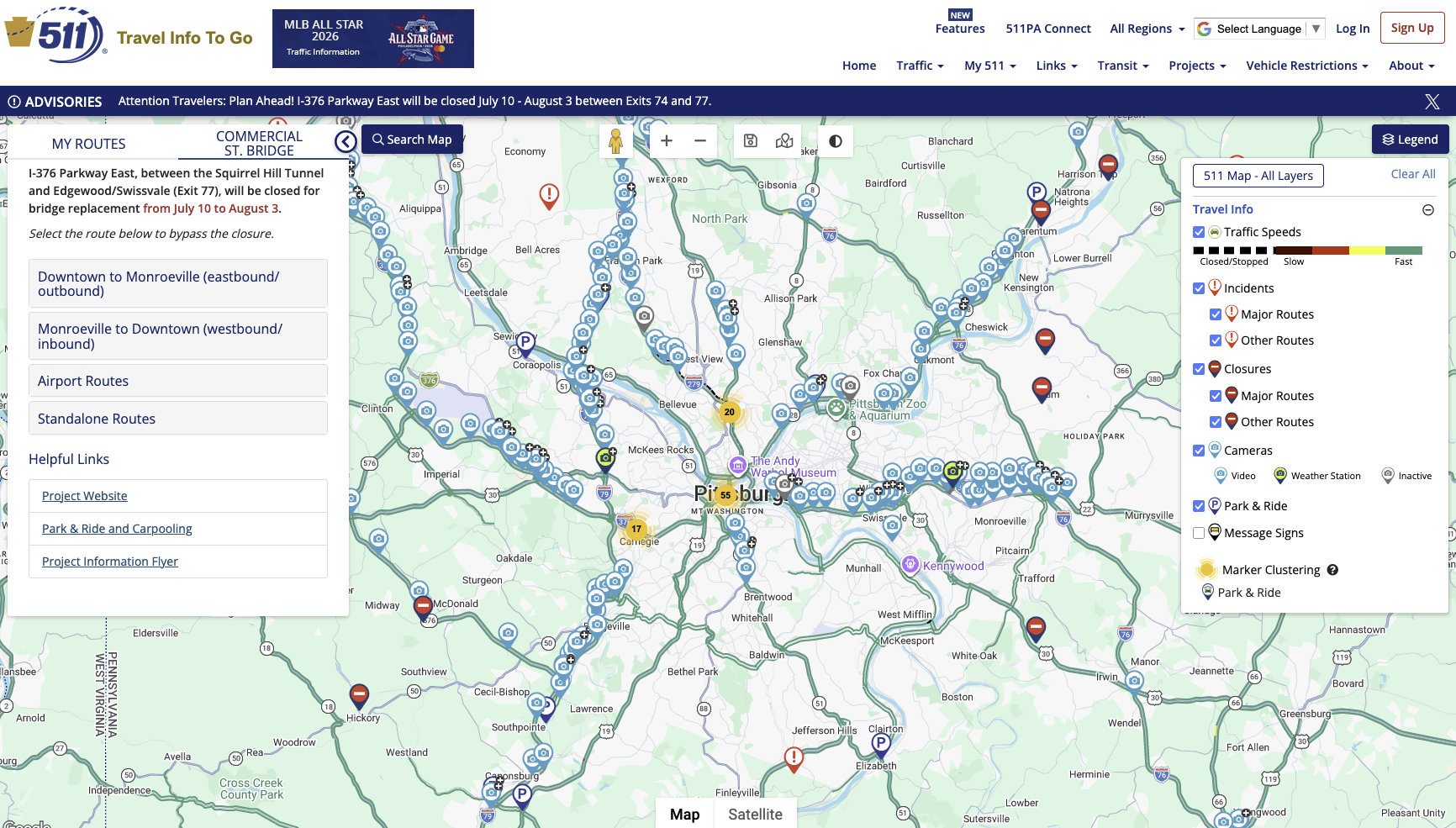
A special 511PA page is now live from PennDOT with real-time travel estimates for the detour and alternate routes. Travelers are encouraged to check their intended route using the 511PA app or website to learn exactly what to expect on the roadways before embarking on their commute. As the most comprehensive source of real-time traffic speeds, incidents, closures, live traffic cameras, park-and-ride locations, and more, 511PA should prove to be one of the most comprehensive resources for commuters during this extended closure of I-376 Parkway East.
Scroll below for more details on the 511PA mobile app and website.
In response to a request for "any tips to make the closure easier on me," PennDOT's Frequently Asked Questions encourages all travelers to:
- Plan Ahead. Review detour maps and allow extra travel time if you must drive in the area. Expect heavy delays.
- Use Remote Work Options if available. If your employer offers teleworking or flexible schedules, take advantage of these options to reduce traffic demand.
- Carpool or Use Transit. Explore public transportation alternatives to reduce congestion. Find a Park and Ride lot near you here or learn about more commuting options like public transit and biking here.
- Be prepared. Have all supplies you will need while waiting in heavy traffic (including snacks and water for your passengers, good music or an audiobook to listen to, comfortable clothing, sunglasses, and anything else that allows you to drive comfortably).
Pennsylvania's Distracted Driving Law prohibits the use of handheld mobile devices while operating a vehicle.
Full enforcement of Pennsylvania's Paul Miller's Law (Act 18) is active – meaning that law enforcement can stop drivers and issue fines to motorists in violation of the law which prohibits drivers from holding, supporting, or physically interacting with a cell phone or mobile device for any reason including texting, scrolling social media, or even looking at the screen while stopped in traffic or at a red light.
Hands-free technology is fully permitted via Bluetooth, Apple CarPlay, Android Auto, and voice commands, as well as use of a properly mounted GPS, and emergency calls to 911. Violation of the law is considered a primary offense itself, so police do not need another reason to pull you over; they can stop you solely for holding your phone.
Preparing for the modified commuting routes in the 25 days ahead:
For more details about the project, PennDOT has published a series of Frequently Asked Questions along side a comprehensive set of detour maps, planning documents, and public meeting material archives on the dedicated PennDOT Project page here.
Alternatives to driving alone:
With more than 50 park-and-ride locations conveniently located throughout the region including those from Westmoreland Transit and Pittsburgh Regional Transit, one of the best ways to mitigate the impacts felt on commuters during this extended closure period is riding transit.
Pittsburgh Regional Transit recommendations include:
- Ride from the bus stop closest to home. Whenever possible, commuters should begin their trip by bus rather than attempting to drive closer to Oakland or Downtown Pittsburgh. Getting on the bus sooner helps reduce traffic, frees up road space for buses and other vehicles, and keeps everyone moving more efficiently.
- Use the Martin Luther King Jr. East Busway. Those without nearby bus service are encouraged to drive to one of PRT's East Busway park and ride lots (or lots served by bus routes heading to the East Busway.) The East Busway is a dedicated bus-only roadway that bypasses traffic and provides fast and reliable service between eastern Allegheny County and Downtown Pittsburgh, with convenient connections to Downtown, Oakland, Shadyside, and East Liberty.
- For more information, visit rideprt.org/commercialstbridge.
- Park and Ride locations most relevant to commuters who will be impacted by the upcoming closure include:
- Alpine Village Park and Ride
- 1559 Golden Mile Hwy Monroeville, PA 15146
- Parking spaces: 245 – Cost to park: Free
- Served by: P12 -Holiday Park Flyer
- Monroeville Mall Park and Ride
- 200 Mall Circle Dr, Monroeville Mall, Monroeville, PA 15146 (By Dick's Sporting Goods)
- Parking spaces: 240 – Cost to park: Free
- Served by: P67-Monroeville Flyer, 67-Monroeville (recommended for Downtown access), and P68-Braddock Hills Flyer
- Beulah Church Park and Ride (Beulah Presbyterian Church)
- 2500 McCrady Rd, Churchill, PA 15235
- Parking spaces: 100 – Cost to park: Free
- Served by: P67-Monroeville Flyer, P16-Penn Hills Flyer, 67-Monroeville
- Forest Hills Park and Ride
- 2601 Ardmore Blvd Pittsburgh, PA 15221
- Parking spaces: 168 – Cost to park: Free
- Served by: 69-Trafford, P69-Trafford Flyer, P76-Lincoln Highway Flyer
- Wilkinsburg Park and Ride (Wilkinsburg Station, East Busway)
- 450 Brushton Ave. Pittsburgh, PA 15208 (additional entrance at Wallace Avenue at Pitt Street)
- Parking spaces: 734 – Cost to park: Free
- Served by: P1-East Busway-All Stops (to Downtown), P3-East Busway Oakland (to Oakland)
- Additional Park and Ride Option if the East Busway Park and Ride lots reach capacity, riders may also consider:
- Duquesne Park and Ride
- Route Duquesne Boulevard at Library Place, Duquesne, PA 15110
- Parking spaces: 311 – Cost to park: Free
- Served by: P7-McKeesport Flyer, 61C-McKeesport-Homestead, 59-Mon Valley
- Alpine Village Park and Ride
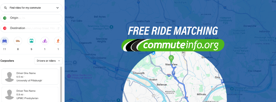
Joining an existing carpool or creating a new one by registering with CommuteInfo to create a free Ride Matching Profile to discover others who live near/along your expected travel routes who may also have similar destinations and schedules. Participation does not require commuters to share their exact locations to be listed in the ride-matching database and participation is easy.
The Trip Planner tool from CommuteInfo not only works for finding shared rides for your daily commute, it is a valuable tool for finding shared rides for other travel, as well, including single trips like doctor's visit, shopping, nights out, or any other reason you're traveling. Moreover, the Trip Planner tool will show not only driving options, but transit, biking, and other options, as well.
What to expect on the roadways during the closure, and the best resources for real-time traffic speeds, incidents, closures, live traffic cameras, park-and-ride locations, and more:
Motorists can expect to see a significant amount of Detour and directional signage posted along all Interstate, Local, and Alternate Detour routes including digital overhead message boards and temporary portable message board signs.
Visible crosswalks and stop bars have been installed at intersections along Local Detour Routes. PennDOT will be proactively monitoring travel times throughout the area to inform and make modifications to traffic signal timing/phases in order to continually improve and assist with traffic congestion.
Pedestrian crossing phases will be maintained at all signalized intersections along detour routes to ensure that pedestrians can continue to safely cross.
Motorists are encouraged to utilize the 511PA mobile app and website from PennDOT which now offers "Drive Mode" for complete turn-by-turn navigation features that will direct motorists to the appropriate/optimal detour route based on their starting point and destination in real-time. With greater access to detailed regional insights than other navigation platforms, the 511PA app allows motorists to visualize traffic speeds, live incidents, closures, traffic cameras, park and ride locations, message signs, and more – all which could be extremely valuable resources for commuters when planning their travel routes in the weeks ahead.
Detour Routes:
To avoid extensive delays on the posted detours, PennDOT has also shared the following "Alternate Routes" for travelers to consider in addition to the Local and Interstate Detours – each of which routes motorists further north or south of the city which should help them avoid the most significant impacts of the closure:
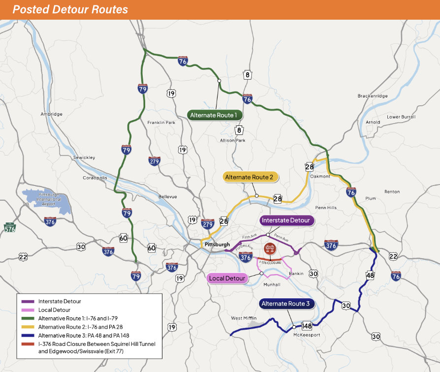
- Alternate Route1: I-76 and I-79
- Guides interstate travelers north of the work zone using I-76 West (PA Turnpike, toll road) to I-79 South. The initial I-76 leg of Alternate Route 1 intersects with Rt 8 and Rt 19, as well. And the I-79 leg of Alternate Route 1 intersects with I-279 Parkway North, Rt 60, and I-376 Parkway East after the work zone.
- Alternate Route 2: I-76 and Route 28
- Also utilizes I-76 West (PA turnpike, toll road) but exits to Rt 28 after crossing the Allegheny River near Oakmont keeping motorists much closer to the city than Alt Route 1, making connections to multiple area neighborhoods possible by intersecting with Rt 8, 62nd Street Bridge, 40th Street Bridge, I-279 Parkway North, and I-376 Parkway East after the work zone.
- Alternate Route 3: Route 48 and Route 148
- Guides interstate travelers south of the work zone using Rt 48 in Monroeville to Rt 30 in the East McKeesport/Forest Hills area and Rt 148 in the McKeesport area to ultimately reach neighborhoods south of Pittsburgh like West Mifflin where motorists can continue to Rt 885 North or Rt 51 North to reconnect with I-376 Parkway East after the work zone, as well.
- Rt 30 (Ardmore Blvd) will experience long-term lane closures, as well, to help the flow of traffic with a single-lane closure in both directions between Morrow Road & Brinton Road
For local motorists and Oakland area commuters traveling inbound:
* Police will assist drivers at major intersections along the detour routes. *
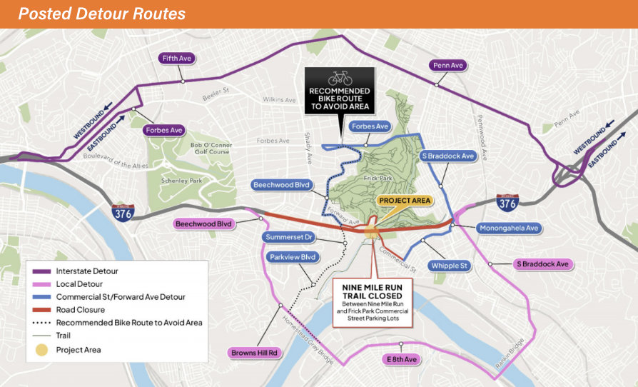
- Inbound toward the Squirrel Hill area can choose to exit I-376 at Edgewood/Swissvale (Exit 77) to utilize S Braddock Ave through Regent Squre to Forbes Ave and Beechwood Blvd.
- To assist with the flow of traffic, S Braddock Ave traffic phases have been modified to reduce southbound traffic to a single-lane between Monongahela Ave and Allenby Ave.
- And northbound S Braddock Ave will now have two lanes of traffic in the same area
- Additionally, the Edgewood/Swissvale exit ramp configuration has been modified to allow left-hand traffic lane at the end of the ramp to continue to turn left onto southbound S Braddock Ave, but the right lane will only allow traffic to turn right onto northbound S Braddock Ave – no left turns will be permitted from the right-hand lane of the ramp.
- Inbound toward the Swissvale area can exit I-376 at Edgewood/Swissvale (Exit 77) to utilize S Braddock Ave and Monongahela Ave to Whipple St.
- Inbound traffic can also choose to exit I-376 at Edgewood/Swissvale (Exit 77) to utilize S Braddock Ave to continue to the Rankin Bridge into Homestead to then travel westbound on E 8th Ave across the Homestead Grays Bridge to Browns Hill Rd and Parkview Blvd/Summerset Dr to connect with Beechwood Blvd in the Squirrel Hill area. By staying on Browns Hill to reach Beechwood Blvd, travelers can then ultimately return to Westbound I-376 Parkway East to proceed further into the city after the closure.
- Inbound traffic can also choose to exit I-376 earlier at Wilkinsburg (Exit 78B) to access a detour route that utilizes Penn Ave to Fifth Avenue and travels through Shadyside and Oakland to ultimately return to Westbound I-376 Parkway East to proceed further into the city – or local traffic can connect to adjacent neighborhoods along the route.
For local motorists and Oakland area commuters traveling outbound:
* Police will assist drivers at major intersections along the detour routes. *
- Eastbound travelers following the posted Interstate Detour route will be directed to exit I-376 at Forbes Ave/Oakland (Exit 72A) to utilize Forbes Avenue to Fifth Ave and Penn Ave to ultimately reconnect with I-376 after the work zone.
- To help the flow traffic through the area, the Boulevard of the Allies will experience a single-lane closure in each direction between McDevitt Place & the Boulevard of the Allies slip ramp from Fifth Ave
- The ramp from Blvd of the Allies to westbound I-376 will remain open to traffic during the closure
- And the posted Local Detour route will direct travelers to I-376 at Squirrel Hill/Homestead (Exit 74; just before the closure) and following Beechwood Blvd to Browns Hill Rd over the Homestead Grays Bridge, E 8th Ave over the Rankin Bridge, and north on to S Braddock Ave to reconnect with I-376 after the work zone.
City of Pittsburgh temporary Right of Way construction moratorium:
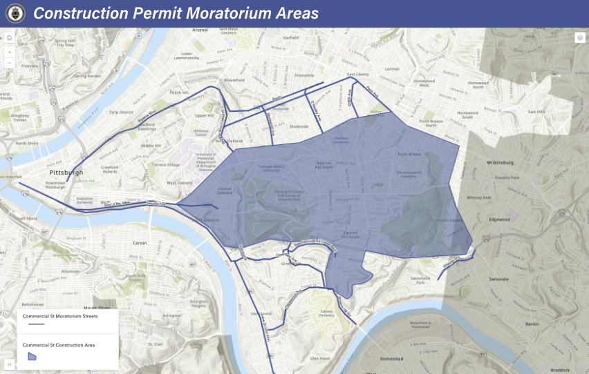
In anticipation of this closure, the City of Pittsburgh has initiated a temporary Right of Way construction moratorium for utilities along the detour route and impacted streets through August 8 to help manage the flow of traffic during the closure. Other construction activities that would typically require travel lane closures will not be permitted during this time along all routes/areas denoted on this map from the City which includes:
Bigelow Blvd, Centre Ave, Baum Blvd, Blvd of the Allies, Morewood Ave, S Negley Ave, Shady Ave, Penn Ave, Swinburne St, Irvine St, Hazelwood Ave, Greenfield Ave, Beechwood Blvd, Browns Hill Rd, Whipple St, Monongahela Ave, and the bulk of Central Oakland, South Oakland, Squirrel Hill, Point Breeze, and the Frick Park side of Regent Square.
This applies to travel lanes, so note that most residential permits (moving permits, dumpsters, and sidewalks) will still be eligible for permitted construction activities.
Note: During the closure period, PennDOT will be assuming control of traffic signal timings along detour routes, and asks that any calls related to the Commercial Street Bridge closure or detour routes be directed to PennDOT, not the City's 3-1-1 service which would typically manage calls regarding traffic signals and congestion complaints.
About the project:
The I-376 Commercial Street Bridge Replacement Project will utilize Accelerated Bridge Construction Techniques to laterally slide the new bridge onto the existing alignment of I-376 Parkway East. It will be one of the largest lateral slide projects performed in Pennsylvania.
The $95 million project located between the Edgewood/Swissvale (Exit 77) interchange and Squirrel Hill Tunnel in Edgewood and Swissvale boroughs began in June 2024 with the reconstruction of the westbound I-376 off-ramp to Forest Hills/Wilkinsburg (Exit 78B).
Currently scheduled for July 10 through August 3, 2026, motorists can expect a 25-day full closure and detour of I-376 Parkway East in both directions. The overall project is anticipated to conclude in the summer of 2027.
Staying up-to-date:
To help keep travelers informed as work progresses, PennDOT has created an email distribution list for I-376 Parkway East traffic advisories and construction updates. Subscribe using the Parkway East online sign-up form.
Updates can also be found on the dedicated I-376 Commercial Street Bridge project page (maintained by PennDOT) or by following the Regional PennDOT page on X @511PAPittsburgh and the Greater Pittsburgh Area PennDOT Facebook group.
Travelers can always check on live conditions on major roads/interstates by visiting www.511PA.com – a free, 24/7 service from PennDOT providindg traffic delay warnings, weather forecasts, traffic speed information, and access to more than 1,200 traffic cameras. 511PA is also available through a smartphone application for iPhone and Android devices or by calling 5-1-1.
Source: PennDOT, City of Pittsburgh, Pittsburgh Regional Transit, 511PA, CommuteInfo


